Introduction to Diving and Snorkelling in the Whitsundays

The many islands of the Cumberland Group with their fringing coral reefs offer a wide range of easily accessible sites for diving and snorkelling. It is possible to find somewhere that is protected in almost any weather, so that snorkelling and diving can be enjoyed virtually 365 days a year, even when Reef excursions elsewhere along the coast are being cancelled because of wind. For this reason the area has become a popular destination for both the novice and experienced diver. It is also a gateway to the Great Barrier Reef, which lies about 34 nautical miles to the north-east of the Whitsunday mainland, about two hours or so by fast dive boat (or slightly longer in a motorised catamaran, which makes a few stops at island resorts on the way to and from the Reef). The fleet of charter boats that depart daily for the islands and the Reef offer a number of ways for snorkelling enthusiasts and divers to explore the underwater world. These include:

  • general day trips to the Great Barrier Reef aboard fast catamarans each capable of carrying over a hundred tourists and sightseers. These vessels tie up at a large pontoon permanently moored at the Reef, and guests are free to go snorkelling on their own or on guided tours; dive instructors on board organise scuba diving for both beginners and certified divers;
  • day trips to the islands aboard charter sailboats catering for general sightseers, with a bit of swimming, sunbaking, island exploring, snorkelling and, if arrangements are made in advance, diving for certified divers;
  • day trips to the islands aboard boats catering exclusively for divers and snorkellers, both experienced and inexperienced – a leisurely day with up to two dives at a fringing reef and plenty of snorkelling time;
  • day dive trips to the Great Barrier Reef aboard purpose-oriented dive boats; the program includes two dives – an ideal trip for the diver or keen snorkeller who wants top diving but has limited time;
  • dive trips of 1-5 nights duration to the Great Barrier Reef, with virtually unlimited diving, including night diving; these trips offer the best value for keen divers;
  • overnight trips to the islands for both diving and snorkelling as well as island exploration.

Certified divers should remember that it’s essential to carry your certification card with you or you will not be able to dive (other than as a beginner, with an instructor). It’s necessary to carry your log book as well.

How to Rent a Yacht in the Whitsundays

Bareboat yacht charter

bareboat_interiorBareboat means ‘You are the skipper, your friends the crew’, but these boats are anything but ‘bare’, usually being very well equipped. Both power boats and sail boats with auxiliary engines are available, ranging in length from about 7 metres (containing 4 berths) up to 15 metres (10 berths). As a rule of thumb, for maximum comfort, the crew should number two fewer than the maximum number of berths on the yacht.

How to go about a bareboat charter

Bareboat charter bookings are best made directly with the charter company but in some cases may be made through a travel agent. A deposit is required at the time of booking, which is held until the completion of the charter. The balance of the charter fee is usually payable 60 days before the charter begins. Travel insurance is recommended in case it is necessary to cancel.

How much experience is necessary?

Prospective charterers need no formal qualifications. For your own peace of mind someone in the crew should have some experience handling a boat. The crew is given a briefing and checkout aboard the yacht before setting off, at which time the skipper will need to demonstrate that he or she can handle the vessel. The charter company may request that a professional skipper go along for a day or two (at the charterer’s expense) if there is doubt about the competence of the skipper and crew.

How long to charter?

Charters are measured in nights aboard the vessel. They usually begin at midday, and the first afternoon is largely taken up with briefing and being checked out aboard the yacht. The first night will therefore be spent at, or close to, the port of departure (most companies insist that yachts are anchored by 4.00 pm due to the difficulty of seeing fringing reefs when the sun is at a low angle). Charters end on the morning of the final day, so the last night out needs to be spent at an anchorage not too far from home base. So, out of a week’s charter, this leaves five nights of real freedom of choice of anchorages, making a seven-night charter the practical minimum if one is to have enough time to see something of the area without imitating a road-runner.

What type of boats are available?

Charter vessels come in a variety of shapes and sizes. Monohulls (one hull) and Catamarans (two hulls) are available as either sailboats or motorboats. Sailboats are a fun way to experience the peace and tranquility of the area – though not as fast as motor boats, they can’t always cover as much distance in a day. Catamarans offer more space than monohulls, though some people prefer the motion of a monohull in a seaway. Ultimately the choice comes down to personal preference and budget. Most charter companies can provide detailed specifications of their available choices.

bravaria_sailing

A typical sailing monohull charter yacht

cat_sailing

A typical sailing catamaran charter yacht

cruiser

A typical charter motor cruiser

cruiser_cat

A typical charter motor catamaran


A cruising itinerary

The central group of islands are within easy reach of the mainland and island charter bases, and these islands offer many choices of anchorages which have appeal for different reasons; for example, some offer excellent snorkelling, some offer fishing, some have good beaches for swimming, some have resorts. Beware of being too ambitious in drawing up an itinerary. Everyone always wants to see as much of the islands as possible, but just as spending only one night in each city on a world trip can prove exhausting, going to a different anchorage every night may defeat the purpose of a truly relaxing holiday. In practice it’s nice to stay a few nights at some destinations to get into the relaxed rhythm of life aboard, doing only what’s necessary to survive and not thinking about moving on to the next port straight away.

The central islands are the most popular, having the pick of the all-weather anchorages. The southern islands are less frequently visited and may appeal to those seeking greater solitude.

Several of the islands have resorts, some of which welcome visitors in boats provided they register prior to arrival and pay a mooring fee. In most cases this fee gives you the keys to the resort facilities. A stopover at a resort can be a pleasant break in a cruise, making a land-fall and having a night out.

Charter costs

The costs of a bareboat charter include the hire of the yacht, food, marine park fee, and perhaps a few extras, such as mooring fees when visiting an island resort. Charter companies offer a complete provisioning service which takes all the work and worry out of procuring food and planning meals. Several standards of provisioning, from ‘basic’ to ‘gourmet’, are available. Alternatively, charterers can do all the shopping and loading the food aboard themselves, which takes time out of the holiday, or they can provide a shopping list in advance and have the company buy to order (for which a service fee is charged). The cost of a bareboat holiday can become relatively inexpensive if the cost of hiring the boat is divided among a number of crew.

Crewed charters

ragamuffinFor anyone who doesn’t want the responsibility of skippering a yacht on their own, crewed charter vessels operate in the Whitsundays. These vessels come with a licensed skipper and assistant, who run the boat and pamper their guests. Sometimes the guests wish to take over the sailing and decision making, in which case the professional skipper and assistant are usually quite willing to simply become part of the crew. For some charterers this situation offers the best of both worlds being able to skipper the boat themselves while being free of some of the restrictions (and responsibilities) under which bareboat charterers operate, such as the limited charter area (which does not include the Barrier Reef), the need to be anchored by 4.00 pm, and so on.

Another variation on the theme is hiring a bareboat and arranging to have a professional skipper as well, in which case the charterer pays the normal costs of the bareboat plus the additional fee for the skipper and his/her food.

Snorkelling Tips for the Whitsundays

Snorkelling

Snorkelling is one of the best ways to appreciate a coral reef – in shallow water where the sunlight is bright and the colours of the reef can really be appreciated. Snorkelling requires little equipment, and one can become totally absorbed observing the wide variety of corals or watching reef creatures going about their business in their own environment. A few hours of snorkelling practice before departing on a holiday, particularly for those who are new to it or who haven’t done it for several years, will be well rewarded when the time comes, because the brush-up on basic skills will make it easier to relax in the water, which is the key to enjoyment.

Equipment for snorkelling

All that’s needed is a face mask, snorkel, and fins. Its important to have a mask that fits well, for a leaking mask is not only annoying but it interferes with relaxing. Anyone who intends doing much snorkelling should consider purchasing their own mask rather than leaving it to chance that they’ll find a good fit among those provided by a cruise operator. And, it’s wise to purchase a mask at a dive shop rather than a supermarket, for example, because dive shops stock a wider range, and they know how a mask is supposed to fit. Test the mask by holding it against the face with the index finger, making sure that all hair is away from the part that seals around the face, then breathe in gently through the nose. The mask will be sucked against the face and should stay there without being held, even when the head is shaken gently from side to side.

Snorkels come in a variety of models, some with features such as adjustable mouth pieces and purge valves, which make them very comfortable to use, but basically a snorkel is just a simple tube, and the simplest model can be quite adequate. They’re not expensive, so when buying a mask, its a good idea to get the snorkel as well, and that way they will always be together in your bag, properly assembled.

Fins come in three or four size ranges, and it’s usually quite easy to find a pair that fits among those provided by the cruise operator.

Water temperature in the Whitsundays

The water in the Whitsundays is relatively warm all year round, but even so, most snorkellers wearing only a swimsuit find that 20-30 minutes is about as long as they can go without beginning to get chilled. A wetsuit with short sleeves and short pants (a ‘shorty’) may give some added comfort in the cooler months, although the minimum average temperature in mid-winter (21°C) is certainly not too cold for ordinary swimming.

Basic skills

Enjoyable snorkelling depends on one’s being able to lie face down in the water completely relaxed, keeping the body flat on the surface and breathing easily. Being relaxed is the key to staying parallel with the bottom, which is the correct position for viewing. If the body is tense, the feet and legs have a tendency to sink, and you find yourself churning the water to stay afloat, perhaps even kicking the bottom if you’re in shallow water, which will certainly frighten away any wildlife that you might hope to see. Newcomers to snorkelling should practise in the shallow end of a swimming pool or near a beach (where it’s easy to stand up) until breathing through the snorkel feels natural.

Finning is an almost straight-legged action, with knees slightly bent. Some say it helps to imagine having splints on your legs. It’s sometimes easier to get the feel of it on your back.

Watch out for currents and for sunburn

Surface currents can be quite strong in the Whitsundays, particularly at times of spring tides. Keep an eye on the boat to see that you haven’t drifted too far away.

Sunburn can be a potential hazard for snorkellers because one feels no heat, and it’s possible to get a burn on the back of the legs and upper back while absorbed in the underwater scenery. Always put on plenty of water-resistant sunscreen, or wear a T-shirt; some snorkellers wear a Lycra suit, or shirt and trousers, which gives good protection from the sun and also protection against scrapes and scratches.

When in the water

There are few aggressive creatures to be encountered, although some are curious about snorkellers just as snorkellers are curious about them. It’s a good idea when entering foreign territory to behave like a guest in someone else’s house. In this state of mind, interaction with the local inhabitants will almost certainly be polite and pleasant. As a general rule it’s wise to be a passive observer and not to handle the animals.

Don’t splash around on the surface making a lot of noise, impersonating a wounded fish; you may send out the wrong signals. Marine creatures depend on a spectrum of low-frequency vibrations for communication, navigation, and for detecting wounded prey.

Fishing in the Whitsunday Islands

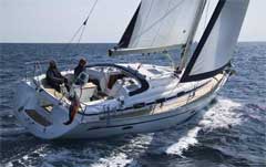
The Whitsundays are perhaps most renowned for game fishing. It is Australia’s prime bill-fishing area, and during the spring and summer months game fishermen come from around the world in hopes of catching a record sailfish, or perhaps a black marlin or bluefin tuna. Over the years many light-tackle records have fallen in the Whitsundays. Amateur anglers do not require a fishing licence in Queesland, although it is unlawful to sell fish without a permit.

Please be aware that there are strict marine parks zoning rules that apply to fishing in the area. See 100 Magic Miles for zoning maps.

Reef fishing

Coral reef fishing is the preoccupation of local fishermen and can be done almost anywhere among and between the islands (other than in no-fishing zones). For those inexperienced at fishing around coral, there are a few tricks that may improve one’s luck. Fishing in coral requires line of at least a 25-kilogram breaking strain, not so much because a huge fish is waiting to pull you out of the dinghy but because coral is murder on fishing gear. Always have plenty of spares on hand. Thin line will, in short order, be chewed to pieces by coral, and fish living around coral tend to take the bait and run for cover under the nearest boulder. A line attached to a fleeing fish can be quickly severed, and it may also cut the fingers, which is why many coral fishermen tape their finger joints. Keep enough tension on the line to register bites and to avoid snagging. The weight of sinker can be adjusted to suit the current.

Fish over the edge of the reef one hour before or after high tide for best results (neap tides are better): early morning and evening are also better than when the sun is high. Night-time on a rising tide can be excellent. Trolling along the edge of a reef may also produce dividends.

Baits readily available in the Whitsundays are prawns, squid, Western Australian pilchards, small fish known locally as ‘herring’ and garfish. If you have a throw-net, small fresh fish from the shallows make excellent bait. A few suggestions about tackle are given later.

Estuary fishing

The Whitsunday mainland coast is studded with mangrove inlets that can yield good catches, and on some of the larger islands, such as Whitsunday and Hook, there are deep embayments with mangrove areas that also can reward the angler. As the tide runs out of estuaries and creeks, predator fish look for baitfish that hide around sheltering ‘snags’ or which are being flushed from streams and gutters on the flats and out into the main creek. During the last half of the runout and the first part of the rising tide these areas can be a good place to drop a lure or a live bait. Some of the bigger fish hang around the deeper holes and channels.

Where best to fish for reef and estuary species

This is the million dollar question, and regard with suspicion any ‘hot tips’ that are other than pretty general in nature. It is impossible to pinpoint exact locations both because these are constantly changing but also because one can easily be a matter of metres off the right place – for example, a particular deep hole. Professional fishermen take years to locate productive fishing spots, and even when they think they know where to go, they often find that they have to keep moving to find the fish. Good spots go cold; months later they may become productive again. Some general locations that are popular with amateurs and which usually yield results are:

  • The Maze: located at the southern end of the Stepping Stones, this dive site is literally a maze of canyons, caves and crevices and relatively shallow (5-15 metres). Large fish are often found in the caves and under ledges. Angelfish are also common. Minimum current within the maze;
  • Hawaii: this large solitary Stepping Stone is located near the northern end of the chain. It drops to nearly 20 metres on the seaward side. Plenty of big fish life but also plenty of current at mid-tide;
  • Cluster of Four: as the name implies, four medium-sized stones in close proximity have created some excellent terrain for exploring – deep canyons and narrow crevices full of whip corals and large fish life. Some current on outside.
  • The Lost Stone: at the northern end of the chain, the stones seem to disappear but are actually just deeper, rising to within 5 metres of the surface. Very good fish life, medium- to large-sized. Fairly deep dive, 8-30 metres. Current at mid-tide.

Game fishing

The Whitsundays are a renowned game-fishing area, particularly for billfish. Game-fishing charter boats operate from the mainland and from several of the islands.

In the winter months, the Whitsunday’s experience big runs of Spanish mackerel -beginning mid to late May and running until late September or early October, although mackerel can caught any time of year.

In summer, the Whitsundays are a prime billfish area – black marlin, swordfish, sailfish – and tuna are caught in large numbers from October through April, although the latter may also be caught year round. Tournaments are held throughout the year for a number of different species, with major meetings in November and December in quest of billfish.

Game fishing takes place around the islands and out at the Barrier Reef (weather permitting). Mackerel can be caught anywhere, but the best locations are the outlying islands from Deloraine, the Edward Group, Minstrel Rocks, around past Pinnacle Point at the top of Hook Island to Dolphin Point, Hayman Island. ‘The Paddock’, which is the open water just north-east of Hayman and Hook islands, yields some magnificent game fish.

Tuna can be caught right amongst the islands. Experienced anglers look for birds diving on the water, a sure sign in season that there are tuna. One tactic employed for hooking tuna is to run just upwind of the feeding school and cast across and through the school with a spinning outfit, such as a small chrome spinner with treble hooks hanging off the back. This tactic avoids ‘spooking’ the fish, which sometimes happens when trolling around tuna. Run upwind, which will facilitate casting, and shut down the motor: in this way its possible to get within 6-10 metres.

Bilifish are found in the shipping channel, between the islands and the Great Barrier Reef, in deep water where there are lots of bait fish in the summer months. Marlin range in size from 10 to 125 kilograms, the average being 30 to 50 kilograms.

The great majority of billfish caught in the Whitsundays are tagged and released.

Rigs for fishing coral reefs, estuaries and for trolling

tackle

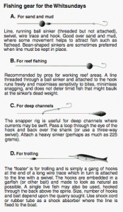
A rod may have its advantages when fishing from rocks on the mainland, but hand lines are easier to manage on a boat A large diameter casting reel makes hand-line management much easier.

The illustration represents the most popular rigs with local fishermen. A, B and C may all be used for reef or estuary fishing, for bottom fishing over sand, mud, near bommies or around reefs. A and B are preferred in reef fishing as they are light: the important basic principle in all rigs is to use the minimum amount of wire trace, the smallest number of swivels and the lightest possible sinker. Too much hardware makes it difficult to register bites and increases the risk of the line being snagged on coral or some other obstruction. Running sinkers (through which the line can easily pass) help timid fish to go with the bait without having to drag a weight that might otherwise deter them. Some fishermen prefer beanshaped sinkers instead of ball sinkers as the bean keeps the line in place more effectively. Rig A is good over sand or mud, as some movement helps to attract fish such as flathead. Rig C is sometimes called a snapper rig and is used in deep channels. The sinker may weigh as much as 225 grams. Rig D, the ‘floater’, is simply a gang of hooks (the size to be determined by the quarry sought) generally used to catch surface swimming fish such as mackerel.

Garfish is popular bait for mackerel, usually on a piece of wire 30-35 centimetres long with two or three ganged hooks run into the belly of the bait. In front of this some of the professionals use a coloured plastic squid (any bright colour will do), about 12 centimetres long, with a barrel sinker in the front end to keep it underwater when trolling at 5 knots or so. When trolling with a rig other than a rod, its a good idea to have some shock absorber in the line, perhaps a bit of bicycle tube or a shock cord tied between the line and where it is secured.

Do’s and don’ts

If you’re unfamiliar with fishing in Queensland, check out the following web site for a rundown on some do’s and don’t’s:

http://www.daff.qld.gov.au/fisheries

There are seven ‘no-take’ species of fishes, four because they are poisonous (see 100 Magic Miles, page 93), and three which are totally protected because they are endangered. These are:

  • Potato cod
  • Queensland groper
  • Hump-headed Maori wrasse

potato_cod

Above: Potato Cod

qld_groper

Above: Queensland Groper

maori_wrasse

Above: Hump-headed Maori Wrasse


Fishing is prohibited in Marine National Park zones (green areas).

In Conservation Park zones (yellow), fishing is permitted with the use of only one hook on one hand-held line or rod (per person); no set lines are permitted. Trolling for pelagic fishes is allowed.

Spear fishing

Limited spearfishing is allowed in the General Use (light blue), Habitat Protection (dark blue) and Conservation Park (yellow) Zones and means fishing with a spear or speargun not using a powerhead, a firearm, a light, or underwater breathing apparatus other than a snorkel. It. Spearfishing in yellow zones that lie within Public Appreciation Areas is not permitted (see 100 Magic Miles pages 112–113 for zoning information). Public Appreciation Areas are shown as broken pink lines on the zoning map. A person must not have a loaded speargun in his or her possession out of the water.

Spear guns and spears may only be used by persons aged 15 years. Power heads are not permitted. Spear fishing is totally prohibited in all Marine National Park zones and in the following areas in the Whitsundays:

  • Brampton and Carlisle Islands: waters between the islands.
  • Seaforth Island.
  • Lindeman Island: the western and southern sides.
  • Long Island: the western side.
  • South Molle Island: the northern side.
  • West Molle Island (Daydream Island): surrounding waters.
  • Hook Island: the eastern, south eastern and southern sides.


Seasonal restictions, legal sizes and bag limits

Fishing is an extremely popular recreation in the Great Barrier Reef Marine Park as well as an important commercial activity and, to protect a seriously diminishing resource, some restrictions, including minimum and maximum size limits and bag limits (maximum number taken), have had to be implemented for species that are under heavy pressure from fishing. Check that you have the latest information on size and bag limits:

http://www.daff.qld.gov.au/fisheries

Coral reef fin fish

The Queensland Government has announced the Coral reef fin fish closed season dates for the next five years which will provide certainty and long-term planning for fishers. Dates in advance assist fishers in their planning.

The closure dates are:

Year Closure 1 Closure 2
2014 21 October to 25 October 19 November to 23 November
2015 10 October to 14 October 9 November to 13 November
2016 28 October to 1 November 26 November to 30 November
2017 17 October to 21 October 15 November to 19 November
2018 6 October to 10 October 5 November to 9 November

The closure dates coincide with the new moon when key coral reef fish species aggregate to spawn. The dates have been scientifically reviewed, and October and November have been found to be the months of highest effectiveness for closures to protect coral reef fin fish.

Closed seasons are vital to allow stocks to replenish to ensure there are healthy fish stocks for current and future generations of Queensland fishers.

The closures apply to coral reef fin fish only, so fishers can still enjoy fishing for a wide range of other fish during the closure period.

The closures will be in place from the northern tip of Cape York to Bundaberg in the south (the southern boundary is at latitude 24º 50’S). The eastern boundary of the closure is the same as the eastern boundary of the Great Barrier Reef Marine Park.

Purpose of size and bag limits

The purpose of minimum size limits is to protect fish until they grow to maturity and can have at least one spawning cycle. Maximum size limits have been introduced to protect large groper and cod. Any fish falling outside the size limits must be released. Bag limits help to conserve heavily exploited species and spread the catch more equitably among fishers.

Anglers are not supposed to mutilate any fish so that the fish inspector can’t determine what’s been caught. If fish are filleted, skin must be left on. Fisheries inspectors make regular checks of vessels, and the penalties are quite heavy for possession of undersized or too many fish.

Oysters

Oysters may be taken only for immediate consumption on the spot in most of the Whitsundays, except in the totally protected Marine National Park zones where they may not be taken at all. Under Queensland fisheries legislation you may not collect oysters in a container to eat later.

Identifying your fish

The best way to identify fish caught in the Whitsundays is to ask a local fisherman. Some assistance may also be found in two very good books on fishes of Queensland and the Barrier Reef region, Guide to Fishes, by E.M. Grant, and Fishes of the Great Barrier Reef and Coral Sea, by J. Randall, G. Allen and R. Steene.

Fish poisoning

There are a few fishes in Queensland which are known to cause tropical fish poisoning (ciguatera) and which should not be eaten:

  • Chinaman fish
  • Paddle tail
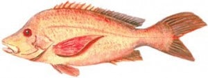
  • Red bream (see 100 Magic Miles page 93 to identify these)
  • Barracouta
  • Moray eel.

chinaman

Above: Chinaman Fish

juvenile_chinaman

Above: Juvenile Chinaman Fish

paddletail

Above: Paddletail

It’s a good idea to check locally to see that others have not been put on the list temporarily (fish can become temporarily ciguatoxic in a particular locality). Generally, larger fishes are more likely to be ciguatoxic. Avoid eating any fish larger than 4 kilograms, and don’t eat repeated meals from the same large fish. Puffer fishes are inherently poisonous and should never be eaten.

Get this information and more in the latest edition of 100 Magic Miles of the Great Barrier Reef – The Whitsunday Islands, or pick up a copy of The Whitsundays Book

Fishing Trip Operators

Introduction to the Whitsundays

The Whitsundays are a group of more than 150 islands and islets off the sub-tropical central Queensland coast of Australia between approximately 20° and 21° south latitude.

Among the world’s best cruising grounds, the islands offer an abundance of yacht anchorages each within easy sailing distance from the next.

Most of the islands are unspoilt national parks; at this time, five have resorts.

The brilliant turquoise of the waters surrounding the Whitsundays is caused by the scattering of light by particles of fine sediments that come from the river systems of the adjacent mainland.

Huge tides (typically 3–5 metres in rise and fall) that sweep this part of the coast keep these sediments stirred up and scatter the sunlight, in the same way that scattering of light gives the sky its blue colour.

View from HammoView from Hamilton Island, surveying the vibrant turquoise waters of the Whitsunday Passage


The Whitsundays are a popular destination for holidaymakers of all kinds and for those who just enjoy being on or in the water. The unspoilt nature of the islands makes it possible to feel that one is making a discovery or setting foot where no one has gone before.

Langford sceneThe Whitsundays are among the world’s finest cruisng grounds


Discovery and origins

James CookThe islands were made known to Europeans by the English explorer, James Cook, in 1770, but Australian aborigines knew all about them at least 6000 years before that and probably for even longer, back to the days before they actually were islands. The Whitsundays are the tops of coastal mountains that became cut off from the mainland during the end of the last ice age. The sea attained its current level about 6000 years ago.


COASTLINE

Geology

The islands are of the same geological composition as the adjacent mainland. They are cloaked in eucalypt and pine, with the occasional swathe of vivid green grassland or an occasional shadowy gully of rainforest. Patches of exposed granite betray the islands’ essentially rocky character. Being in subtropical waters where corals grow, they are surrounded by fringing coral reefs that give them a jewel-like appearance when viewed from above. These fringing reefs can provide hours of diversion for scuba divers, snorkellers and those who enjoy fishing.


Bait Reef_2The Whitsunday islands are in warm subtropical waters where corals grow around their shorelines, providing opportunities for snorkelling, diving and fishing.


Neck BayThe islands’ fringing coral reefs impart a jewel-like appearance viewed from the air


Origin of the name ‘Whitsundays’

European discoverer James Cook didn’t name the islands but rather ‘Whitsunday’s Passage’, which was the passage between Cape Conway (20° 22’S, 148° 55’E, the tip of the mainland on the west) and the islands lying to the east of this. That Sunday in June 1770 when he passed through was Whit Sunday, the celebration on the Christian calendar that takes place on the 49th day (7 weeks) after Easter Sunday. The term is derived from Old English meaning “White Sunday”, after the white robes of those newly baptised at Pentecost, the fiftieth day after the second day of the Passover.

Officially they are the ‘Cumberland Islands’

Cook named the surrounding islands ‘Cumberland Isles’, and on his sketch of the area, the label ‘Cumberland Isles’ extends well to the south of Cape Conway and the islands to the east. Cook actually named only one of the islands, Pentecost.

PentecostThe only island Cook named – Pentecost Island


Successive naval surveyors in the 1800s gave names to most of the rest, many names coming from the old county of Cumberland in England (now Cumbria) because the landscape reminded the surveyors of that part of England. Today’s charts show a ‘Whitsunday Group’ (as well as other island groups), but there is no official definition of the ‘Whitsunday islands’. There are over 150 islands, islets and rocks in the Cumberlands, which the hydrographic office considers to be all those from Snare Peak Island in the south (21° 06′ S, 149° 56′ E) to Hayman Island in the north (20° 03 S, 148° 53’E). Someone somewhere along the line in an advertising brochure seized upon the number ’74’ as being the number of ‘Whitsunday islands’, a figure often touted in promotion of the area but which has no apparent basis.

The climate

Shirtsleeve weatherThe Whitsundays have a warm subtropical climate with mild winters and warm to very warm summers. Much of the annual rainfall occurs in the wet season, which is usually January-March, when a considerable portion of rain falls at night. The water is a swimmable temperature year round, and the Queensland sun creates shirt-sleeve weather most of the time.

Whitsunday temperatures and rainfall

Temperatures in degrees Celcius (to convert to approximate Fahrenheit temperatures, double and add 32)

Jan. Apr. July Oct.
Av. daily high (°C) 31 28 23 28
Av. daily low (°C) 25 23 17 21
Days rain (over 0.2 mm) 13 14 5 5
Normal rainfall (mm) 203 115 36 16
Mean sea temp. (°C) 27 26 22 24


Normal annual rainfall – 1445 mm

The southern tropics have occasional cyclones, which can occur in the Whitsundays from November to May, but if they happen at all, are most likely to come in February and March. Queensland has an excellent cyclone warning system that provides plenty of advance notice of an impending cyclone.

The Whitsunday mainland

The mainland coast along the spread of the Whitsunday Islands stretches approximately from the town of Mackay in the south (21° 06’S, 149° 14’E (pop. 82,300) to the coastal villages of Airlie Beach, Cannonvale and Shute Harbour in the north (20° 05’S, 148° 32’E). The Whitsunday Shire (total population appx. 20,000) comprises these three villages as well as the resort islands of Hamilton, Hayman and Daydream and the sugar-farming town of Proserpine about 35 minutes inland by car.

Cannonvale was the earliest settlement in this area and continues to be a residential centre with a growing interest in tourism. Three kilometres to the east of Cannonvale is Airlie Beach, Whitsunday’s resort town and business centre, with holiday accommodation, nightlife, restaurants, tourist booking agencies, shops and a growing number of condominiums.

View from AirlieIslands beckon in the distance looking northwards from Airlie Beach


Airlie_townAirlie Beach is the Whitsundays’ resort town and business centre


At Abell Point, a short distance back towards Cannonvale, is the Abell Point Marina (20° 16’S, 148° 43’E), a boating centre and point of embarkation for the islands and the Great Barrier Reef.

Abel Pt Marina oldAbell Point Marina is the largest mainland marina in the area and a major point of embarkation for the islands and the Great Barrier Reef


Ten kilometres down the road to the south-east of Airlie is Shute Harbour, the best natural harbour for many kilometres up or down the coast. Historically it was the principal jumping-off point for the islands and many island day trips embark from its jetties.

Shute_112Shute Harbour is the best natural harbour on this part of the coast and is one of two main embarkation points for the islands


The Great Barrier Reef

The nearest reefs of the Great Barrier system lie 34 nautical miles north-east of the Whitsunday mainland. It’s about a 2.5 hour trip in one of the fast motorised catamarans that take daily excursions to Hardy Reef. Other vessels carrying scuba divers and snorkellers also do regular trips to the Reef.

Bait Reef_2Bait Reef is the nearest to the Whitsundays of the platform reefs of the Great Barrier Reef proper and is very popular with scuba divers


Fantasea PontoonHardy Reef is the site of a pontoon where visitors can snorkel, dive and sunbake at the Great Barrier Reef


Wrasse feedingThere’s plenty of actiion around the pontoon for the entertainment of young and old

The Cumberland Islands

Cumberlands

Get this information and more in The Whitsundays Book, or pick up a copy of the latest edition of 100 Magic Miles of the Great Barrier Reef – The Whitsunday Islands