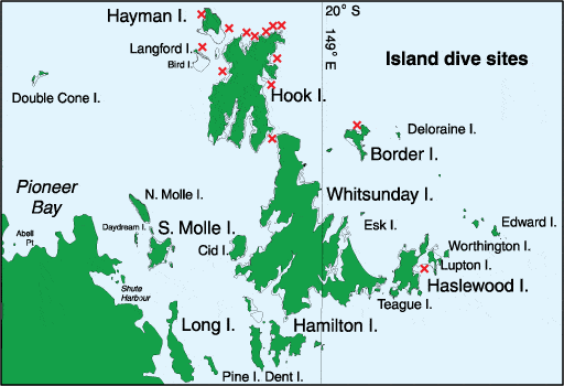
Best Dive Sites in the Whitsunday Islands

Dive and Snorkel Sites

Diving and snorkelling in the area can be done either around the Whitsunday Islands, or further out to sea on the Barrier Reef proper. The quality of the reef and wildlife is better for the latter.

Whitsunday Island Dive Sites

DIVEMAP_Islands

Bird Island

Visibility: 2-12 metres

Diving depth: 2-15 metres

Bottom: Rock in the shallows down to 6-8 metres, then dropping off to coral rubble and silty sand.

This site very open to currents; best to plan a drift dive or stay close to the island. Interesting rock formations down to 8 metres; shallow caves, ledges and gullies. Not a lot of coral, but the fish life can be quite good with large cod, sweetlip and trevally.

Snorkelling: Only mediocre.

Black Island (West Reef)

Visibility: 2-10 metres

Diving depth: 3-12 metres

Bottom: Small, scattered coral heads on a silty sand bottom gently sloping from the beach to 15 metres.

An easy shore dive (as the majority of interesting corals are very near the shore) from the northwestern corner of Black Island. Fish life rather small, but colourful. Current can be strong offshore, particularly near the northern end of the beach.

Snorkelling: Yes, but a bit deep at high tide.

Border Island (Cataran Bay)

Visibility: 2-12 metres

Diving depth: 2-12 metres

Bottom: Good hard coral cover in shallow water to 6 metres with patches of sand. Below 6 metres predominantly small coral heads, coral rubble and silty sand.

Best diving on either side of entrance into bay. Coral reefs are relatively shallow, dominated by large beautiful plate coral. From the top of reef a small wall drops down to 6 metres. Scattered coral bommies continue down to 12 metres. Plenty of gullies and ledges to explore. Fish life average, though some larger sweetlip and cod can be found under the ledges. Inside the bay, current is minimal; however, beware strong currents at the entrance, particularly off the northwest tip.

Snorkelling: Coral very shallow, making for easy snorkelling.

Haslewood Island (Waite Bay)

Visibility: 3-15 metres

Diving depth: 3-18 metres

Bottom: Very good coral cover with scattered small bommies and sand patches in shallow water gradually sloping from 3 metres to 6 metres. Good wall down to 12-18 metres then coral rubble and silty sand. Very diverse dive site. A maze of interesting coral bommies in shallow water from 6 metres. Good quality coral. A descent wall dive from 6 metres to as deep as 18 metres on reef edge. Again, good coral cover, plenty of gullies and ledges to explore. Good fish life of all sizes. Watch for manta rays in the winter months, May to September. Current is not normally a problem except during spring tides. Bay is open to south-easterlies. Can only be dived during light winds or northerlies.

Snorkelling: Best in shallows near beach, though is also very good for the intrepid snorkeller who prefers something a bit deeper on the reef edge.

Hayman Island (Dolphin Point)

Visibility: 3-15 metres

Diving depth: 5-18 metres

Bottom: Rugged terrain of coral outcrops and huge boulders set on coral rubble and sand.

An unusual dive amongst house-sized rock slabs making for great exploration. Large coral bommies at 5-15 metres add to the diversity of the dive. Excellent large fish life for island diving, including trevally, mackerel, barracuda and the odd shark. This is a relatively deep dive with potential currents near the point. Good anchorage in all but northerly winds.

Snorkelling: Not really. Too deep.

Hayman Island (East Reef)

Visibility: 5-15 metres

Diving depth: 2-12 metres

Bottom: Very good coral cover in shallow water (6-8 metres) cut with numerous small canyons. Small bommies and sand-coral rubble from 8 to 15 metres.

A very pretty shallow dive and snorkel site. The shallow coral cover is dominated by large plates, creating numerous small canyons and ledges which make for interesting exploration. Plenty of small, friendly reef fish. Access to this site is difficult due to its exposure to wind from every direction and to currents. A site for very calm days at slack tide.

Snorkelling: Excellent shallow coral.

Hook Island (Alcyonaria Point)

Visibility: 3-15 metres

Diving depth: 3-18 metres

Bottom: Good coral cover with patches of coral rubble and silty sand.

Excellent coral and fish life, particularly along the shallow ledge that runs along the point to Flat Rock. Plate corals dominate the shallow water. Ledge drops vertically with wall penetrated by numerous gullies and small caves. Many colourful soft corals at 10 metres, hence the site name. Large wrasse, cod and sweetlip found at depth. Current can be a problem, particularly at midtide. Anchorage is difficult due to drop-off. Exposed to northerlies and strong south-easterlies.

Snorkelling: Excellent shallow corals but prone to strong current.

Hook Island (Butterfly Bay)

Visibility: 2-10 metres

Diving depth: 5-12 metres

Bottom: Coral cover with large patches of coral rubble and silty sand.

This popular bareboat anchorage offers coral outcrops with shallow walls. Many small, colourful fish. Best of the bommies is found in the centre of the bay, though difficult to locate at high tide. Tidal currents can be a problem as one moves away from the bay edge towards the centre.

Snorkelling: Only along the bay edge or just off the beach.

Hook Island (Mackerel Bay)

Visibility: 2-10 metres

Diving depth: 2-12 metres

Bottom: Good coral cover in shallow water, dropping off to scattered bommies at 7-12 metres.

A dive that is better at some times than at others depending upon visibility. This is a popular dive site during northerlies when most of the more popular sites are untenable. A relatively shallow dive through a mace of coral bommies, which form shallow canyons, ledges and swim-throughs. The fish life is medium in size and quite good. Exposed to southerly winds.

Snorkelling: Visibility adversely affected by the tide. Best during neap tides.

Hook Island (The Pinnacles)

Visibility: 3-15 metres

Diving depth: 3-18 metres

Bottom: Near solid coral cover in shallow water, breaking up into scattered but dense bommies from 5 to 18 metres. Below 18 metres only coral rubble and sand with the odd small coral head.

Arguably the best dive site in the Whitsunday islands – certainly the best hard corals which compare favourably to the Great Barrier Reef. The best dive would be off the western beach, adjacent to the Woodpile and swim east at a depth of 7-15 metres. Large coral bommies dominate the terrain, reaching nearly to the surface. As usual, acropora corals are everywhere but huge porites corals in the shape of huge boulders and massive towers can also be seen. The fish life is medium in size and average in quality. Masts rays are very common in the cooler months, May to September. In the shallow water, particularly off the western beach, the coral cover is nearly solid, mostly staghorn, with only a few sandy patches. The quality of the corals diminishes the further east one goes (towards the rock pinnacles). This site is open to northerly winds and swell from strong south-easterlies.

Snorkelling: Some of the best in the Whitsundays just off the western beach.

Hook Island (Saba Bay)

Visibility: 2-12 metres

Diving depth: 2-15 metres

Bottom: Good coral cover in shallow water, dropping of to scattered bommies at 7-12 metres

As with Mackerel Bay, this is another popular dive site during northerly winds which can be better at some times than others depending upon visibility. The northern end of the bay is studded with numerous small bommies in relatively shallow water, dropping down to 10-15 metres with scattered bommies among coral rubble and sand. Plenty of shallow canyons, ledges and swimthroughs. The fish are small- to medium-sized and in good numbers. Visibility is adversely affected by tide. Best dives during neap tides. Exposed to southerly winds.

Snorkelling: Interesting bommies on both sides of bay.

Hook Island (Stonehaven Anchorage)

Visibility: 2-10 metres

Diving depth: 2-12 metres

Bottom: Scattered small coral heads with a silty sand bottom.

This site offers interesting shallow diving with lots of small marine life including damselfishes. Christmas-tree worms and nudibranches. The coral heads are small but diverse. The visibility is very much controlled by the tides, but is best during the reaps.

Snorkelling: Only at high tide, as can be quite shallow.

Hook Island (The Woodpile)

Visibility: 4-15 metres

Diving depth: 5-30 metres

Bottom: Rock wall drop-off with scattered deep coral and sandy bottom. The unusual rock formation known as the Woodpile has created the best wall dive in the Whitsunday islands. The wall drops down to nearly 30 metres on the point. Best to start the dive about halfway between the beach and the point. Here the wall is covered in soft corals down to 5-7 metres. Below 7 metres, the wall is somewhat devoid of corals but provides some excellent exploring, with large overhanging ledges and shallow caves. Some fairly large black coral trees can be found between 10 and 15 metres. Back away from the wall is a maze of coral bommies, including some large porite corals. Approaching the point the landscape becomes rather barren due to strong currents – an area to be avoided. This site is exposed to northerlies, and swell from strong south-easterlies can make anchoring quite uncomfortable.

Snorkelling: No.

Langford Island (Langford Reef North)

Visibility: 2-10 metres

Diving depth: 3-15 metres

Bottom: Scattered small coral bommies on sandy bottom, gradually sloping from shore to 15 metres. Below 15 metres mostly coral rubble and silty sand.

A very popular day-trip destination for sailors, snorkellers and divers. Best diving is found on north-western end of beach, where current is strongest at mid-tide. Scattered bommies offer an interesting maze to explore. Some shallow walls at the eastern end of the island. The majority of fish life is small but abundant. Expert to encounter tidal currents at all times except slack water. Reasonable protection from all but the strongest wind condition.

Snorkelling: Just offshore along the beach; best towards the island.

Whitsunday Island (The Gardens)

Visibility: 4-15 metres

Diving depth: 5-15 metres

Easy, shallow dive just off Hook Island, very near the Underwater Observatory. Coral cover dominated by large plate corals. Plenty of small friendly reef fish looking for a handout. Occasionally, large pelagic fishes will cruise through. Excellent protection in all wind conditions. Current can be a problem during spring tides.

Snorkelling: Watch current during big tides.

Top 10 Spots for Snorkelling in the Whitsundays

1. The Pinnacles (Hook Island)

Some of the best snorkelling to be had in the Whitsundays, just off the western beach. Coral cover is nearly solid, mostly staghorn, with only a few sandy patches. The quality of the corals diminishes the further east you go. Fish life is medium in size and average in quality, manta rays common in cooler months, May to September. The site is open to northerly winds and swell from strong south-easterlies. Visibility 3-15 metres.

2. Bait Reef

There are various sites at Bait Reef that will provide excellent snorkelling.

At the Southern Face shallow waters are dominated by flat terrain completely covered by hard corals with the odd sand patch. Large turtles, manta rays and some pelagic fishes such as mackerel and barracuda are often seen cruising along the drop-off. Visibility is around 12-30 metres.

The Stepping Stones are a unique feature of Bait Reef. They are made up of 18 or more flat-topped coral pinnacles lined up in a row along the south-west side of the reef. Each pinnacle rises from a depth of 15-25 metres and stops within one metre of the surface. The pinnacles are circular in shape and have vertical sides. Each of the stepping stones is completely covered with coral of all varieties – huge plates on top, soft corals and gorgonian fans on the sides, and vary in size from 15-50 metres in diameter. Small colourful tropical fish swarm around the tops of the stones, large wrasse, sweetlip, cod, trevally, trout and others cruise the canyons, ledges and caves at depth. Manta rays are common from May to September. Visibility is around 10-20 metres.

Other sites at Bait Reef include Manta Ray Drop-off which is home to an excellent coral garden but is very prone to current and Gary’s Inlet which has very good shallow coral at the edge of the inlet. A 100 metre swim to the east at high tide is a beautiful shallow, unnamed lagoon with a couple of resident reef sharks.

3. Henry’s Bommie (Fairey Reef)

Henry’s Bommie reaches from 12 metres to near the surface. The site boasts good coral cover and clouds of tropical fish. Excellent snorkelling with minimal current. Visibility is around 10-20 metres.

4. Little Fairey Inlet (Fairey Reef)

Excellent snorkelling along the wall of the inlet. Swimming along teh wall of the inlet brings you in contact with very good fish life including brightly coloured angelfish, cod, trout and sweetlip. Some current at the opening of the inlet. Visibility 10-20 metres.

5. Tina’s Arm (Fairey Reef)

This is one of the prettiest sites on Fairey Reef and provides excellent snorkelling. Very good coral cover including large porites coral and gorgonian fans. Prone to currents so best to visit at slack water. Visibility 10-20 metres.

6. Alcyonaria Point (Hook Island)

Excellent coral and fish life, especially along the shallow ledge that runs along the point to Flat Rock. Plate corals dominate the shallow waters. Current can be a problem, particularly at mid-tide. Anchorage difficult due to drop-off. Exposed to northerlies and strong south-easterlies. Visibility around 3-15 metres.

7. Butterfly Bay (Hook Island)

Best snorkelling to be found along the western reef ledge deep into the bay. Bottom consists of coral cover with large patches of coral rubble and silty sand. This popular bareboat anchorage offers coral outcrops with shallow walls. Many small, colourful fish. Best of the bommies is found deep in the centre of the bay, though difficult to locate at high tide. Tidal currents can be a problem as one moves away from the bay edge towards the centre. Visibility around 2-10 metres. Diving depth 5-12 metres.

8. East Reef (Hayman Island)

A very pretty shallow dive and snorkel with excellent shallow coral. Coral cover dominated by large plates, creating numerous small canyons and ledges which make for interesting exploration. Plenty of small, friendly fish. However, access to the site is difficult due to its exposure to wind form every direction and to currents. A site for calm days at slack tide. Visibility around 5-15 metres.

9. Saba Bay (Hook Island)

Good coral cover in shallow water, dropping off to scattered bommies at 7-12 metres. As with Mackerel Bay, this is another popular dive site during northerly winds which can be better at some times than others depending on visibility. The northern end of the bay is studded with numerous small bommies in relatively shallow water, dropping down to 10-15 metres with scattered bommies among the coral rubble and sand. Plenty of shallow canyons, ledges and swimthroughs. The fish are small- to medium-sized and in good numbers. Visibility is adversely affected by tide. Best diving during neap tides. Exposed to southerly winds. For snorkelling, there are interesting bommies on both sides of the bay.

10. Cateran Bay (Border Island)

The coral is relatively shallow making for easy snorkelling at this site. Reef dominated by large beautiful plate coral. Inside the bay current is minimal, however beware of strong currents at the entrance, particularly of the north west tip. Visibility 2-12 metres.

For more information on the best snorkelling and diving sites in the Whitsundays, including maps, order your copy of 100 Magic Miles via the online store.

Island Camping in the Whitsunday Islands

Whitsunday Island with Dinghy

Getting ashore on an Island requires a dinghy…

To camp in the Whitsundays is to indulge in what many believe to be the ultimate camping experience – sleeping under the stars on a ‘desert isle’. There are many islands to choose from, and the final choice of site may depend on whether you wish to get away from it all, or to be more gregarious. The choice may also depend on a willingness to ‘rough it’ (with no facilities) or to have creature comforts such as picnic tables, a shelter, bush toilets, and possibly, in season, water at the site. Transport to the islands is another key factor.

Once you have selected a suitable campsite and arranged transport, a camping permit can be purchased several ways: first, by visiting the Queensland Government’s website (www.nprsr.qld.gov.au); by ringing the QPWS camping permits information line on 13 74 68; or call in at the QPWS headquarters (during normal office hours), corner Mandalay and Shute Harbour roads, Airlie Beach (about three kilometres out of Airlie Beach towards Shute Harbour). Once you have booked and paid for your permit, you will be given a booking number and issued a camping tent tag.

Getting to an island campsite
Ferry services that specialise in camper and kayaker drop-offs are the easiest option. They are used to dealing with the needs of campers and kayakers, and they usually have all the necessary equipment available for hire.

Get this information and more, such as campsite locations, getting to the islands and tropical tips in the latest edition of , 100 Magic Miles of the Great Barrier Reef – The Whitsunday Islands.

Camping Services

An Introduction to Walking in the Whitsundays

The islands of the Whitsundays have a significant number of tracks that reward walkers with spectacular views of this magic island group. Tracks range from gentle graded climbs through diverse bushland and across grasslands to scrambles up some of the highest promontories in the Whitsundays.

The Whitsunday Ngaro Sea Trail provides the ultimate experience for trekkers, yachtsmen, kayakers and campers to stretch their legs and appreciate some of the finest seascapes in the world and visit some of the oldest sites of human habitation on earth. The walking tracks within the Trail range in level of difficulty and length providing something for everyone.

Other walks can be found on Long Island, Brampton Island, Hamilton Island and Lindeman Island.

Boating in the Whitsundays

For complete information about boating in the Whitsundays, refer to the essential sailing guide for the area, 100 Magic Miles of the Great Barrier Reef – The Whitsunday Islands.

windybayAustralia’s finest cruising grounds, the Whitsundays, offer scores of protected anchorages each within easy reach of the next. The area has the largest bareboat charter fleet (power and sail) in the South Pacific. For those trailing runabouts or trailer sailers, there are a number of launching ramps along the coast from Mackay in the southern Whitsundays to Bowen at the extreme northern end of the area, with several located conveniently in the heart of the area at Shute Harbour, Airlie Beach, Abel Point and Shingley Beach.

Sailing conditions

South-east trade winds fan the Queensland coast from March-April to September-October providing exhilarating sailing conditions, frequently 15-20 knots in strength. From October onwards milder easterlies and north-easterlies are more common. The islands themselves and the Great Barrier Reef to the east create a relatively protected stretch of water (European discoverer James Cook referred to the Whitsunday Passage as “one continued safe harbour”). But when the winds are piping in, the phenomenon of ‘bullets’ (sharp gusts) may be experienced in some anchorages, and good anchoring technique is essential.

Tides

The Whitsundays are subject to 3–4 metre tides which, during times of maximum flood and ebb, create currents that accelerate through the narrow passages between the islands, and when the direction of the wind and tidal currents oppose each other, Whitsunday waters can sometimes be turbulent. Yachts plan their movements to take advantage of currents and to avoid bumpy passage making. The large rise and fall of the water level needs to be considered when anchoring a yacht.

Boating facilities

The area has four marinas, with others under construction.

Location
Entrance lat./Long.
Facilities
Mackay 21° 063’S, 149° 14.0’E 479 berths; full marine services; launching ramp
Laguna Whitsundays 20° 35’S, 148° 41.5’E Current Status Unknown
Hamilton Island 20° 20.8’S, 148° 56.8’E 230 berths; full marine services
Abell Point 20° 15.6’S, 148° 42.6’E 507 berths; full marine services; launching ramp

Hayman Island has a private marina available to those who are also staying at the resort.

trailer_sailorLaunching ramps are available at: the Mackay marina; at Victor Creek (just north-west of Seaforth, for access to the Newry Group and southern Whitsunday islands); at Laguna Whitsundays marina (access to the south-central islands); Shute Harbour (access to the central and northern islands); Airlie Beach/Abell Point/Port of Airlie (3 ramps, for access to the northern and central islands) and at Dingo Beach (access to the northern islands).

Water is generally available only at marina facilities in the Whitsundays.

Skippering a boat in the Whitsundays

Navigation is quite simple among the islands because there are so many prominent landmarks. The ability to interpret a nautical chart is really all that’s required. Anchoring is the most demanding task, and someone in the crew needs to how to set an anchor properly. Good anchoring technique is the key to peaceful, worry-free nights, particularly if fresh trade winds are causing sharp gusts (locally referred to as ‘bullets) to rush over island peaks and down into the anchorages. Those bringing their own boat to the Whitsundays, who may be familiar only with estuary cruising, should be sure that their anchor tackle is suitable for coral cruising, with an adequate length of chain and an anchor rope sufficiently thick to be comfortable to pull on. A lot of scope is sometimes necessary in the Whitsundays, and retrieving the anchor can be hard on the hands.